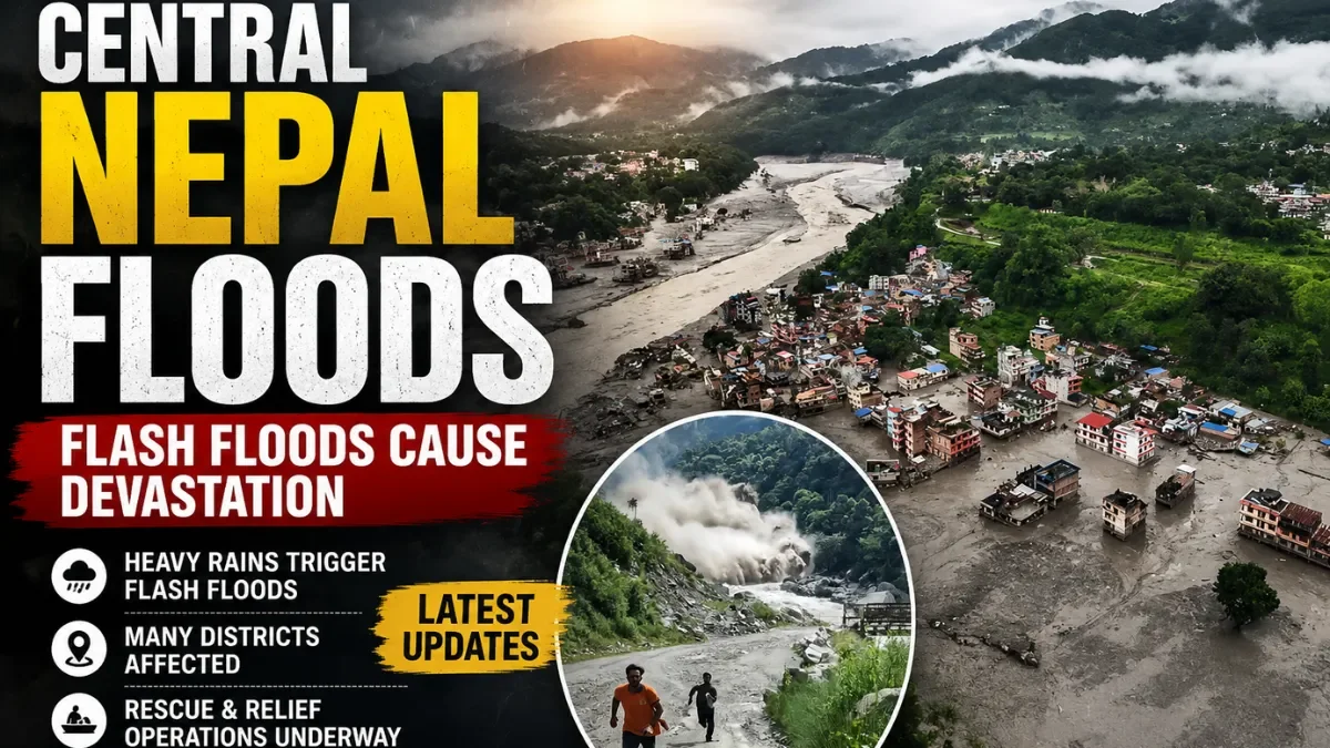
As of the morning of August 28, 2026, Nepal Police have recorded at least 353 deaths, with roughly 826 people still unaccounted for, following the flash floods that tore through Rasuwa, Nuwakot and Dhading districts on August 26. Search-and-rescue teams, backed by drones and additional police units, remain deployed across the affected valleys. Nepal Police have also published a website of unidentified remains to help families trace missing relatives, and have asked the public to rely only on official channels rather than unverified social media claims.
Central Nepal has been affected by a catastrophic flash flood that struck the Bhotekoshi–Trishuli river corridor on the morning of August 26, 2026, sweeping away homes, bridges, roads and hydropower infrastructure across Rasuwa, Nuwakot and Dhading districts. Authorities have not yet finalized a single confirmed death toll or missing-persons count; both figures have risen through multiple updates over the past two days.
What Happened in Central Nepal?
On the morning of August 26, 2026, at around 8:30–8:40 a.m. local time, a sudden and powerful flash flood surged down the Bhotekoshi and Trishuli rivers in Nepal's Rasuwa and Nuwakot districts. Villages including Rasuwagadhi, Timure and Syabrubesi were hit especially hard, with roads, bridges, markets and at least one hydropower site swept away or severely damaged. The flooding also crossed into the Gyirong area of Tibet, on the China side of the border.
Which Areas Are Affected by the Floods?
| Location | What happened | Current status |
|---|---|---|
| Rasuwa district (Rasuwagadhi, Timure, Syabrubesi) | Epicenter of the disaster; villages, roads, bridges, markets and hydropower facilities destroyed or damaged | Active search and rescue; high alert |
| Nuwakot district (Bidur/Trishuli Bazar, Devighat) | Homes and buildings buried in mud and debris downstream of Rasuwa | Rescue and recovery ongoing; residents searching hospitals and morgue lists for missing relatives |
| Dhading district | Flood-affected; placed under high alert along river corridors | High alert |
| Gorkha and Chitwan districts | Not directly struck at the same scale, but placed on high alert as a precaution | High alert; residents told to stay away from riverbanks |
| Gyirong area, Tibet (China) | Flooding and a related mudslide affected the border trade hub | China has confirmed deaths and reported a large number of missing people |
How Many People Have Died or Gone Missing?
This is the least settled part of the story, and readers should expect the numbers to keep changing. Early reporting on August 27 put Nepal's death toll at roughly 157–162, based on Nepal Police figures at that time. By August 28, Nepal Police-sourced updates cited in international coverage put the toll at 353, with about 826 people still missing; a separate compiled tally put confirmed deaths at 359. UNICEF's own figure, drawn from Nepal Police data, cited an estimated 332 deaths including at least 14 children.
Missing-persons estimates also vary by source: some reporting put the missing count at several hundred, while at least one report cited roughly 1,400 people missing overall. A significant share of the missing are foreign nationals — one tally lists at least 644 foreign tourists from 33 countries as missing, including citizens of India, China, the United States, Ukraine, Malaysia, Australia, the United Kingdom and Canada, among others. Missing Nepali nationals reportedly include police officers, Armed Police Force personnel, Nepal Army soldiers, customs officials and hydropower workers.
Authorities had not yet released a single, fully reconciled confirmed figure at the time of publication. Readers looking for the latest number should check Nepal Police's official channels directly, since even major international outlets are citing different snapshots taken at different hours.
What Caused the Central Nepal Flash Floods?
Causes reported by authorities and researchers: Preliminary satellite analysis and assessments from disaster-risk researchers, including specialists at the Kathmandu-based International Centre for Integrated Mountain Development (ICIMOD), indicate the flood was most likely triggered by an ice avalanche or glacial collapse that blocked the Lhende River near the Nepal–China border. When that natural debris dam failed, it released a sudden, large surge of water and sediment down into the Bhotekoshi and Trishuli river system. A magnitude-4.4 earthquake was also recorded in the region on the same morning by the U.S. Geological Survey, though authorities have not confirmed a direct causal link between the quake and the flood.
Background context (not confirmed as direct causes of this specific event): Central Nepal's mountain valleys sit in a region where climate scientists have documented glacial retreat and increasingly unstable high-altitude terrain. Researchers involved in assessing the disaster noted that this river system had flooded once before in the past 14 months. This event was described by at least one glacial-hazards researcher as the worst flooding of this kind he had personally observed in the region — but that is an individual expert's assessment, not an official cause determination.
Which Rivers and Areas Are Under Flood Risk?
The Lhende, Bhotekoshi and Trishuli rivers are at the center of the disaster. As of August 27, Nepal's Department of Hydrology and Meteorology (DHM) flood-monitoring dashboard showed most major monitored rivers nationally as "below warning level and steady," suggesting the immediate rainfall-driven flood risk had eased in many parts of the country. However, this does not mean the danger has passed in the disaster zone: authorities have warned residents along the affected river corridors in Rasuwa, Nuwakot, Dhading, Gorkha and Chitwan to move away from riverbanks because of ongoing risks from unstable slopes, debris and the possibility of secondary flooding.
Rescue and Relief Operations
Nepal Police and the Nepal Army have deployed additional teams, including units with drones, across the affected districts. Rescue workers have used excavators to dig through mud and debris, and sniffer dogs have been brought in to search for survivors and remains. Helicopters have airlifted injured and rescued residents to hospitals in Kathmandu, where family members have been searching for missing relatives. Nepal Police have also published an online database of unidentified and unclaimed remains to help with identification, while urging the public not to spread unverified claims, rumors or deepfakes about the disaster and to rely only on official sources.
Internationally, India's Prime Minister Narendra Modi spoke with Nepal's Prime Minister Balen Shah and pledged humanitarian assistance. UNICEF has said it is supporting emergency health, water and hygiene response for children and families in Rasuwa, Nuwakot and Dhading, estimating that around 17,000 children have been affected. Nepal's Prime Minister has called for national unity and appealed to volunteers, businesses and citizens across the country to contribute to the relief effort.
Roads, Transport and Infrastructure Impact
At least 19 road bridges and roughly 40 kilometers of road have been destroyed or severely damaged, according to reporting from the affected area, disrupting the Kathmandu–Kerung trade route that runs through Rasuwagadhi toward the China border. Multiple hydropower projects in the area have been damaged, and workers at some sites — including one report of dozens of workers from an under-construction hydropower project — remain unaccounted for; these figures are still being reconciled as rescue teams reach affected sites. Water supply systems and telecommunications networks in the flood zone have also been damaged, and at least four health facilities have reportedly been severely affected, limiting access to medical care in the area.
Weather Forecast and Further Flood Risk
Nepal's DHM had, as of August 27, not issued a nationwide flood alert on the scale of the disaster itself; its flood-monitoring stations showed most major rivers below warning level. That said, this is monsoon season in Nepal (roughly June through September), when heavy, localized rainfall and unstable mountain terrain regularly produce flash floods and landslides across the country, sometimes with little warning. Anyone in or near the affected districts should treat official DHM and district administration bulletins — not social media — as the authoritative source for any new rainfall or flood warnings.
What Residents and Travellers Should Know
- Nepal Police have specifically asked the public to stay away from rivers, streams and other flood-affected or high-risk locations in the disaster zone.
- The Kathmandu–Kerung (Rasuwagadhi) route to the China border has been disrupted by damaged roads and bridges; travelers planning to use this route should check current status with Nepali authorities before departing.
- Trekking and tourism routes through the Langtang/Rasuwa region, popular with foreign visitors, have been directly affected; anyone with travel plans in this specific area should check with their embassy and local tour operators rather than assuming normal conditions elsewhere in Nepal apply.
- Families searching for missing relatives, including foreign nationals, are being directed to Nepal Police's official channels and their respective embassies in Kathmandu.
- This is not a nationwide travel warning — the disaster is concentrated in specific north-central districts, and other parts of Nepal, including most of the Kathmandu Valley itself, have not been reported as directly affected by this event.
Central Nepal Floods Timeline
- August 26, 2026, ~8:30–8:40 a.m. — A flash flood surges down the Bhotekoshi/Trishuli river system in Rasuwa district, following a suspected glacial collapse/ice avalanche that blocked the Lhende River. Villages including Rasuwagadhi, Timure and Syabrubesi are hit; a magnitude-4.4 earthquake is also recorded in the region the same morning.
- August 26, 2026 — Flooding also affects Nuwakot district downstream, including Bidur/Trishuli Bazar and Devighat; the Gyirong area of Tibet, China, is affected as well. Early death-toll reports begin at around 13–21 confirmed and climb through the day.
- August 27, 2026 — Nepal Police confirm a death toll in the 157–162 range in early-day reporting, with hundreds of people, many of them foreign tourists, listed as missing; China reports at least 3 dead and roughly 558 missing on its side of the border. Nepal Army and Police deploy further rescue teams; UNICEF reports an estimated 17,000 children affected. Nepal's DHM flood-monitoring shows most rivers nationally below warning level.
- August 27–28, 2026 — Death toll and missing-persons figures continue rising through further police updates, reaching an estimated 332 (UNICEF), and later 353–359 in other reporting, with roughly 826 people still listed as missing in some accounts. Nepal Police launch a website for unidentified remains. Rescue and recovery operations continue in Rasuwa and Nuwakot.
- Ongoing — Search and rescue, identification of remains, and infrastructure assessment continue in Rasuwa, Nuwakot and Dhading districts, with Gorkha and Chitwan under high alert.
8. FAQ
What happened in central Nepal? A powerful flash flood struck the Bhotekoshi and Trishuli river corridor in Nepal's Rasuwa and Nuwakot districts on the morning of August 26, 2026, destroying homes, roads, bridges and hydropower infrastructure. The flooding also affected Dhading district and crossed into Tibet, China. It is one of the deadliest disasters in Nepal in recent years, with search and rescue still active.
What caused the central Nepal flash floods? Preliminary assessments from disaster researchers, including specialists at ICIMOD, point to an ice avalanche or glacial collapse that blocked the Lhende River near the Nepal–China border. When the resulting debris blockage failed, it released a large surge of water downstream into the Bhotekoshi and Trishuli rivers. Nepali authorities have not issued a final, official cause determination.
Which areas of Nepal are affected? The hardest-hit areas are Rasuwa district (particularly Rasuwagadhi, Timure and Syabrubesi) and Nuwakot district (particularly Bidur/Trishuli Bazar and Devighat). Dhading district was also affected, and Gorkha and Chitwan districts have been placed on high alert as a precaution.
How many people have died in the Nepal floods? Reported figures vary because this is a still-developing disaster: early reports on August 27 cited roughly 157–162 deaths, while later police-sourced updates on August 28 put the toll at 353, with a separate tally citing 359. There is no single fully reconciled official total as of publication, and the number is expected to keep rising.
How many people are missing? Estimates range from several hundred to roughly 1,400 people, including a large number of foreign nationals — one tally counts at least 644 foreign tourists from 33 countries among the missing, alongside Nepali security personnel, hydropower workers and civilians. As with the death toll, this figure has not been finalized.
Which rivers are at risk? The Lhende, Bhotekoshi and Trishuli rivers are directly involved in this disaster. As of August 27, most other major rivers monitored by Nepal's Department of Hydrology and Meteorology were below warning level nationally, though authorities have still warned residents near the affected corridors to stay away from riverbanks.
Is more rain expected in central Nepal? Nepal is currently in its monsoon season (roughly June through September), during which sudden, localized heavy rainfall is common and can trigger further flash floods or landslides with little notice. Readers should check Nepal's DHM and district administration bulletins directly for the latest forecasts rather than relying on this article for real-time weather updates.
Are roads affected by the floods? Yes. At least 19 road bridges and roughly 40 km of road have been destroyed or damaged, and the Kathmandu–Kerung trade route through Rasuwagadhi to the China border has been disrupted. Travelers should confirm current road status with Nepali authorities before using routes through the affected districts.
Is it safe to travel to affected areas? The Rasuwa, Nuwakot and Dhading disaster zone, including popular Langtang-region trekking routes, is not safe for casual travel while search, rescue and infrastructure repair are ongoing. This is not a nationwide warning — other parts of Nepal have not been reported as directly affected by this specific event, but travelers with plans in or near the affected districts should check with their embassy and local operators first.
Where can people find official Nepal flood warnings and updates? Nepal's Department of Hydrology and Meteorology (dhm.gov.np) publishes flood monitoring and weather bulletins, and Nepal Police is the primary source for casualty and missing-persons updates. Families searching for missing foreign nationals are being directed to contact their embassies in Kathmandu.