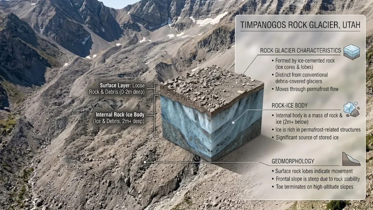
From the surface, the Timpanogos Rock Glacier in Utah's Wasatch Range looks like nothing more than a sprawling pile of rocks and rubble cascading down a mountainside. But beneath that rocky exterior lies a spectacular hidden reservoir: approximately 1.55 million cubic metres of ice — enough frozen water to fill roughly 600 Olympic-sized swimming pools or approximately the volume of the Great Pyramid of Giza.
This discovery, published on August 26, 2026, in the Journal of Geophysical Research by researchers from the University of Utah, marks the first detailed three-dimensional mapping of ice content in a Utah rock glacier using an innovative gravity survey method. The team, led by former graduate student Bronson Cvijanovich and supervised by geophysics professor Michael Thorne and glaciology professor Leif Anderson, took 232 gravity measurements across the glacier's surface and used advanced statistical modeling to reconstruct the hidden ice body in 3-D.
The findings reveal that the glacier's ice-rich core is approximately 83% ice and 17% rock debris by volume, with an average ice thickness of 18.8 metres (about 62 feet) and deeper sections reaching roughly 150 feet (about 46 metres). But beyond the impressive numbers, the discovery raises important questions about mountain water storage, climate monitoring, and how much ice remains hidden beneath the world's rocky mountain slopes.
Here's what scientists found, how they found it, and what it means for our understanding of mountain ice in a warming world.
Scientists Found a Huge Store of Ice Beneath Timpanogos
The Timpanogos Rock Glacier, located above Emerald Lake in the Wasatch Range near Mount Timpanogos (approximately 30 miles southeast of Salt Lake City), is one of 836 rock glaciers documented in Utah using satellite imagery. While rock glaciers have been mapped from space, their internal ice content — how much ice is actually buried beneath the rocks, how thick it is, and how it's distributed — has remained largely unknown until now.
Key Findings:
Ice Volume: 1.55 million cubic metres (1.55 × 10⁶ m³) of ice
Water Equivalent: Approximately 1.5 million cubic metres of frozen water (about 396 million gallons, or roughly 1 billion metric tons)
Ice-Rich Core Composition: 83% ice, 17% rock/debris by volume
Entire Glacier Composition: 72% ice, 28% debris by volume (using a two-layer model)
Average Ice Thickness: 18.8 metres (approximately 62 feet)
Maximum Ice Thickness: Approximately 150 feet (approximately 46 metres) in deeper sections
Study Period: Field work conducted in fall 2024 (six forays to the glacier between August and October)
Publication: August 26, 2026, in the Journal of Geophysical Research (DOI: 10.1029/2026JF009214)
What This Means in Practical Terms:
The 1.55 million cubic metres of ice represents a significant amount of frozen water stored in Utah's mountains. To put this in perspective:
600 Olympic swimming pools: A standard Olympic swimming pool holds approximately 2,500 cubic metres of water, so 1.55 million cubic metres equals roughly 620 pools
Great Pyramid of Giza: The volume is approximately comparable to the Great Pyramid (Khufu's pyramid has an estimated volume of about 2.6 million cubic metres, so the comparison is approximate but gives a sense of scale)
1 billion tons: The ice mass represents approximately 1 billion metric tons of frozen water
Important Note: These figures are modelled estimates based on gravity measurements and statistical inversion, not direct measurements. The researchers used Bayesian statistical methods, which provide a range of possible ice distributions with associated probabilities. While the estimates are scientifically robust, they carry inherent uncertainty — the actual ice volume could be somewhat higher or lower than the 1.55 million cubic metre estimate.
What Is a Rock Glacier?
Before diving into how scientists detected the ice, it's important to understand what a rock glacier actually is — because it's quite different from the conventional image of a glacier.
Rock Glacier vs. Conventional Glacier
Conventional Glacier:
Visible ice surface (white/blue ice you can see)
Forms from accumulated snow that compacts into ice over time
Flows downhill under its own weight
Often has visible crevasses, icefalls, and moraines
Examples: glaciers in the Alps, Himalayas, Alaska
Rock Glacier:
Surface appears as a pile of rocks, boulders, and debris (no visible ice from the surface)
Ice is buried beneath the rocky surface
Also flows downhill, but much more slowly than conventional glaciers (typically centimetres to metres per year)
Looks like a slow-moving river of rocks from the outside
Common in high mountain environments where rockfalls from steep cliffs bury snow and ice
How Can Ice Exist Beneath Rocks?
The ice in a rock glacier survives beneath the rocky surface for several reasons:
1. Insulation Effect:
The thick layer of rocks and debris on top acts as insulation, protecting the ice from direct sunlight and warm air. This is similar to how a thick blanket keeps you warm — the rock layer keeps the ice cold by shielding it from temperature fluctuations.
2. Permafrost Conditions:
At high elevations in mountain ranges like the Wasatch, temperatures remain cold enough year-round to maintain frozen ground (permafrost). The ice can persist for centuries or millennia as long as the climate remains cold enough.
3. Continuous Replenishment:
Rock glaciers aren't static. Rockfalls from steep cliffs above continuously add new debris to the surface, while snow that accumulates in the upper parts gets buried and eventually compacts into ice. This ongoing process means rock glaciers can actually grow or maintain their ice content even as surface rocks shift and move.
How Do Rock Glaciers Form?
According to the University of Utah research team's mathematical model (described in a companion study), rock glaciers form through a specific process:
Snow Accumulation: Snow accumulates in high mountain cirques (bowl-shaped valleys) or below steep cliffs
Rockfall Burial: Rocks and boulders fall from steep slopes above, burying the snow
Compaction: Over time, the buried snow compacts into ice under pressure
Slow Flow: The ice-debris mixture slowly flows downhill, similar to a conventional glacier but much more slowly
Ongoing Process: New rockfalls continue to add debris to the surface, while new snow gets buried and turns to ice
Important: The Utah researchers found that rock glaciers in the Wasatch Range are not remnants from the last Ice Age (which peaked 21,000-18,000 years ago). Instead, they formed over the thousands of years after Ice Age glaciers melted away, as ongoing rockfall buried snow in high mountain valleys. This means rock glaciers are active, ongoing features of the mountain landscape, not just ancient relics.
Why Do Scientists Study Rock Glaciers?
Rock glaciers matter for several reasons:
1. Water Storage:
They store significant amounts of frozen water in mountain environments. As the climate warms, this ice could potentially melt and contribute to streams, rivers, and groundwater — though the rate and timing of any such contribution are complex and not fully understood.
2. Climate Indicators:
Because rock glaciers contain ice that's sensitive to temperature changes, they can serve as indicators of climate change in mountain regions. Changes in rock glacier flow rates, surface features, or ice content can signal warming trends.
3. Mountain Hydrology:
Understanding how much ice is stored in rock glaciers helps scientists better model mountain water resources, which are critical for downstream communities, agriculture, and ecosystems.
4. Hazard Assessment:
Rock glaciers can pose hazards if they destabilize or if their ice melts rapidly. Understanding their ice content helps assess potential risks.
5. Global Ice Inventory:
With an estimated 50,000 rock glaciers worldwide, understanding their ice content is important for completing the global inventory of mountain ice — which is crucial for sea level rise projections and water resource planning.
How Scientists Detected Ice Beneath the Rocks
The most innovative aspect of this research isn't just the discovery of how much ice is there — it's how the scientists figured it out without drilling, digging, or using ground-penetrating radar.
The Gravity Survey Method
The research team used a technique called gravity surveying, which relies on a fundamental principle of physics: different materials have different densities, and these density differences create tiny variations in gravitational acceleration that can be measured.
Here's how it works:
Step 1: Understanding Density Differences
Rock density: Typical mountain rock (granite, quartzite, etc.) has a density of approximately 2,600-2,800 kilograms per cubic metre
Ice density: Ice has a density of approximately 917 kilograms per cubic metre
The contrast: Rock is approximately 3 times denser than ice
This density difference is crucial. When you measure gravity at the surface, areas with thicker buried ice will have a slightly weaker gravitational pull than areas with more rock, because ice is less dense.
Step 2: Taking Gravity Measurements
Between August and October 2024, Bronson Cvijanovich led six field forays to the Timpanogos Rock Glacier. At each location, he:
Set up a state-of-the-art gravimeter (a highly sensitive instrument that measures gravitational acceleration)
Took a gravity reading at that specific point
Moved to the next measurement point, approximately 25 metres (80 feet) away
Repeated the process across the entire glacier
Total measurements: 232 gravity readings in a grid pattern across the glacier
Why 232 measurements?
More measurements = better resolution of the 3-D ice body
A grid pattern with 25-metre spacing provides systematic coverage of the entire glacier
This density of measurements allows scientists to create a detailed 3-D model, not just a rough estimate
Fewer measurements would result in a coarser, less accurate model
Step 3: Correcting the Measurements
Raw gravity measurements aren't ready to use directly. They must be corrected for several factors that affect gravity readings:
Elevation: Gravity decreases with height above sea level (you're farther from Earth's center)
Latitude: Earth's gravity varies slightly with latitude (Earth is not a perfect sphere)
Terrain: Nearby mountains and valleys affect local gravity
Sun and Moon: Tidal effects from celestial bodies cause tiny gravity variations (yes, the Moon's gravity affects your measurements!)
After applying all these corrections, the remaining variations in gravity are primarily due to subsurface density differences — in this case, the contrast between rock and ice.
Step 4: 3-D Bayesian Inversion
This is where the advanced mathematics comes in. The researchers used a technique called 3-D Bayesian inversion to convert the 232 gravity measurements into a three-dimensional model of the buried ice.
What is Bayesian inversion?
It's a statistical method that incorporates prior knowledge and uncertainty
Instead of producing a single "best guess" model, it produces a range of possible ice distributions with associated probabilities
It accounts for the fact that gravity measurements have inherent uncertainty
The result is not just "here's where the ice is" but "here's where the ice is most likely to be, with this level of confidence"
Computational effort: The researchers spent "months of computation time" running the Bayesian inversion models, according to professor Michael Thorne.
Step 5: Creating the 3-D Ice Model
The final output is a three-dimensional picture of the ice body beneath the rocks — similar to how a CT scanner creates a 3-D image of bones and tissues inside the human body, but using gravity instead of X-rays.
The model shows:
Where the ice is thickest
Where it's thinner
The overall shape and volume of the ice body
The estimated ice content (83% ice in the ice-rich core)
Why Use Gravity Instead of Other Methods?
You might wonder: why not just use ground-penetrating radar, seismic methods, or drill holes to measure the ice directly?
Advantages of gravity surveying:
1. Non-Destructive:
No drilling or digging required
Doesn't disturb the fragile mountain environment
Important for protected or sensitive areas
2. Works Through Rocky Debris:
Ground-penetrating radar can be limited by thick, heterogeneous rock debris
Seismic methods require good contact with the ground, which is difficult on boulder fields
Gravity measurements work regardless of surface conditions
3. Provides 3-D Picture:
Drilling only gives you information at specific points (like poking a straw into a cake to see what's inside)
Gravity surveying provides a continuous 3-D model of the entire ice body
Much more comprehensive than point measurements
4. Logistically Feasible:
A gravimeter is portable (though heavy and sensitive)
Can be carried by researchers hiking to remote locations
Doesn't require heavy equipment or infrastructure
Limitations:
Lower resolution than direct methods (drilling, radar)
Model-dependent (results depend on the inversion method and assumptions)
Requires careful corrections for elevation, terrain, etc.
Computationally intensive
The Result: A Detailed 3-D Ice Map
The gravity survey and Bayesian inversion produced the first detailed 3-D map of ice content in a Utah rock glacier. The model revealed:
Ice volume: 1.55 million cubic metres
Average thickness: 18.8 metres
Maximum thickness: ~46 metres (150 feet) in deeper sections
Ice-rich core: 83% ice, 17% debris by volume
Entire glacier: 72% ice, 28% debris by volume (two-layer model)
This level of detail was previously impossible to achieve without extensive drilling or radar surveys, which would have been far more expensive, time-consuming, and environmentally disruptive.
How Much Ice Is Actually There?
The 1.55 million cubic metres figure is the headline number, but what does it actually represent?
Ice Volume vs. Water Equivalent
Ice Volume: 1.55 million cubic metres of ice (the physical volume of the ice body)
Water Equivalent: When ice melts, it becomes water. Since ice is slightly less dense than water (ice: ~917 kg/m³, water: 1,000 kg/m³), 1.55 million cubic metres of ice would produce approximately 1.42 million cubic metres of water — roughly 396 million gallons or 1 billion metric tons of water.
Important: The study reports the ice volume (1.55 million cubic metres), not the water equivalent. Some news reports have conflated these, but they're slightly different (though close enough for most practical purposes).
Uncertainty in the Estimate
It's crucial to understand that 1.55 million cubic metres is a modelled estimate, not a direct measurement.
Sources of uncertainty:
Gravity measurement uncertainty: Gravimeters are extremely precise, but not perfect
Correction uncertainties: Elevation, terrain, and other corrections have their own uncertainties
Inversion assumptions: The Bayesian inversion method makes certain assumptions about the subsurface
Density assumptions: The model assumes certain densities for rock and ice, which may vary in reality
Model resolution: The 25-metre spacing between measurements means small-scale variations in ice thickness may not be captured
What this means: The actual ice volume could be somewhat higher or lower than 1.55 million cubic metres. The researchers don't report a specific uncertainty range in the available coverage, but Bayesian methods typically provide confidence intervals. A reasonable estimate might be ±10-20% uncertainty, meaning the actual volume could be in the range of approximately 1.2-1.9 million cubic metres.
Scientific honesty: It's important not to present 1.55 million cubic metres as an exact, precise measurement. It's a scientifically robust estimate, but it carries inherent uncertainty — as all modelled estimates do.
Comparison to Other Ice Bodies
How does 1.55 million cubic metres compare?
Small conventional glacier: A small mountain glacier might contain 10-100 million cubic metres of ice, so Timpanogos Rock Glacier is smaller than a typical conventional glacier
Large rock glacier: For a rock glacier, 1.55 million cubic metres is substantial — among the larger rock glaciers studied in detail
Utah context: With 836 rock glaciers in Utah, if each held similar ice volumes, the total would be enormous (though they vary greatly in size)
Global context: With ~50,000 rock glaciers worldwide, the cumulative ice volume is significant (estimated at ~48 gigatons of water, as discussed below)
What Does 1.55 Million Cubic Metres of Ice Look Like?
Numbers like "1.55 million cubic metres" are hard to visualize. Here are some comparisons to help make sense of the scale:
Olympic Swimming Pools
Approximately 600 Olympic-sized swimming pools
A standard Olympic swimming pool is 50 metres long, 25 metres wide, and 2 metres deep, giving a volume of 2,500 cubic metres.
1.55 million cubic metres ÷ 2,500 cubic metres per pool = 620 pools
News reports round this to "about 600 pools" — a reasonable approximation.
Visualizing 600 pools:
If you lined up 600 Olympic pools end-to-end, they would stretch approximately 30 kilometres (18.6 miles)
If you filled 600 pools and then emptied them into a single container, you'd have roughly the same volume as the Timpanogos ice
Great Pyramid of Giza
Approximately the volume of the Great Pyramid
The Great Pyramid of Giza (Khufu's pyramid) has an estimated volume of approximately 2.6 million cubic metres. The Timpanogos ice volume (1.55 million cubic metres) is about 60% of the pyramid's volume — so the comparison is approximate but gives a sense of the massive scale.
Visualizing the pyramid comparison:
Imagine the Great Pyramid — one of the largest stone structures ever built
The Timpanogos ice volume is somewhat smaller but in the same ballpark
This helps convey that we're talking about a truly massive amount of ice, not just a small patch
Other Comparisons
Football fields:
If you spread 1.55 million cubic metres of ice over a standard American football field (including end zones, approximately 5,350 square metres), it would be approximately 290 metres (950 feet) deep
If spread over 10 football fields, it would still be 29 metres (95 feet) deep
Water supply:
396 million gallons of water could supply approximately 13,000 average American households for a year (assuming ~300 gallons per household per day)
This is a rough comparison and doesn't account for the practical challenges of accessing and using this water
Weight:
1.55 million cubic metres of ice weighs approximately 1.42 billion kilograms (1.42 million metric tons, or about 1 billion tons as reported)
That's equivalent to approximately 14,000 fully loaded Boeing 747 aircraft
Why These Comparisons Matter
These comparisons aren't just for dramatic effect — they help readers understand the practical significance of the discovery:
600 pools conveys that this is a substantial water resource, not just a scientific curiosity
Great Pyramid emphasizes the geological scale of the ice body
Household water supply hints at potential water resource implications (though with major caveats, as discussed below)
Why Is the Ice Buried Under Rocks?
The question of why ice exists beneath rocks — rather than as a visible glacier — is central to understanding rock glaciers.
The Insulation Effect
The thick layer of rocks and debris on top of the ice serves as a highly effective insulator:
How it works:
Summer: The rock layer shields the ice from direct sunlight and warm air, preventing rapid melting
Winter: The rock layer also insulates the ice from extreme cold air, maintaining relatively stable temperatures
Year-round: The rock layer reduces temperature fluctuations, creating a more stable environment for the ice
Analogy: Think of how a thick blanket keeps you warm in winter — it traps heat. Similarly, the rock layer traps cold, protecting the ice from warming.
Permafrost Conditions
At the high elevations where rock glaciers form (typically above 2,500-3,000 metres in mid-latitude mountains like the Wasatch), temperatures remain cold enough year-round to maintain permafrost — ground that remains frozen for at least two consecutive years, often for centuries or millennia.
Key factors:
High elevation: Colder temperatures at altitude
Latitude: Mid-latitude mountains (like the Wasatch) are cold enough at high elevations
Shading: North-facing slopes receive less direct sunlight, staying colder
Snow cover: Winter snow insulates the ground, preventing extreme cold from penetrating deeply
The ice in rock glaciers can persist as long as these permafrost conditions are maintained. If the climate warms significantly, the ice could begin to melt — but the rock layer slows this process considerably compared to exposed ice.
Ongoing Formation
As the University of Utah researchers' mathematical model shows, rock glaciers aren't static relics — they're actively forming and evolving:
The process:
Rockfalls from steep cliffs above continuously add new debris to the surface
Snow accumulates in the upper parts of the rock glacier
Burial: New rockfalls bury the snow
Compaction: Over time (years to decades), the buried snow compacts into ice under pressure
Flow: The ice-debris mixture slowly flows downhill (typically centimetres to metres per year)
This ongoing process means that rock glaciers can maintain or even grow their ice content even as surface rocks shift and move — as long as rockfalls continue to supply debris and snow continues to accumulate.
Why Doesn't the Ice Melt?
Given that Utah experiences warm summers, why doesn't the buried ice melt?
Reasons:
Insulation: The rock layer (often several metres thick) shields the ice from summer warmth
Elevation: High elevations (Timpanogos Rock Glacier is above 3,000 metres / 10,000 feet) remain cold even in summer
Permafrost: The ground remains frozen year-round at these elevations
Limited water flow: Meltwater from the surface doesn't easily penetrate the thick rock layer to reach the ice
Cold air drainage: Cold air drains down into the rock glacier at night, helping maintain cold conditions
However: If the climate warms significantly, or if the rock layer is disturbed (by landslides, human activity, etc.), the ice could become vulnerable to melting. This is a key concern for climate scientists studying rock glaciers.
Could This Ice Become a Water Source?
One of the most intriguing questions raised by this discovery is whether the buried ice could serve as a water source — particularly for a state like Utah, which faces ongoing water challenges.
The Short Answer: Potentially, But It's Complicated
Could the ice eventually become water?
Yes — if it melts, the ice would become liquid water that could potentially flow into streams, rivers, or groundwater.
Could it contribute to streams or groundwater?
Potentially — but the rate and timing of any such contribution are uncertain and depend on many factors.
How long could it remain frozen?
As long as permafrost conditions persist — which could be decades, centuries, or longer, depending on climate change.
What controls its stability?
Temperature: Warmer temperatures increase melt risk
Rock layer thickness: Thicker rock layers provide better insulation
Climate change: Long-term warming trends are the biggest threat to rock glacier ice
Disturbance: Landslides, human activity, or other disturbances could expose ice to melting
Practical Considerations
Even if the ice could theoretically become water, there are significant practical challenges:
1. Accessibility:
The Timpanogos Rock Glacier is in remote, high-elevation terrain (above 3,000 metres / 10,000 feet)
Access requires hiking approximately 5 miles with 3,500 feet of elevation gain (as the researchers did)
Building infrastructure to access and extract the water would be extremely expensive and environmentally disruptive
2. Extraction Challenges:
The ice is buried beneath metres of rock and debris
Extracting it would require extensive mining or drilling operations
The environmental impact of such operations in a sensitive mountain ecosystem would be significant
3. Water Rights and Regulations:
Water in Utah is heavily regulated
Extracting water from a rock glacier would require permits, environmental reviews, and potentially face legal challenges
Downstream water users (agriculture, municipalities, ecosystems) have existing water rights that would need to be considered
4. Economic Viability:
The cost of extracting and transporting water from a high-elevation rock glacier would likely far exceed the value of the water
Cheaper alternatives (water conservation, recycling, desalination, etc.) would likely be more economically viable
5. Environmental Concerns:
Rock glaciers are sensitive ecosystems
Disturbing them could have unintended consequences (destabilization, increased melt rates, habitat disruption)
Many rock glaciers are in protected or semi-protected areas where extraction would be prohibited
What Scientists Say
According to the University of Utah coverage, researchers describe the ice as a "possible water source" but emphasize that this is a theoretical possibility, not a practical recommendation.
Professor Leif Anderson (glaciology) noted: "There's a lot of ice that's hidden in Utah's mountains. When we are high in the mountains and walking across loose rocks or rubble, you don't realize there could be 120 feet (37 metres) of ice buried beneath your feet."
Key point: The researchers are highlighting the existence of this ice as part of Utah's water inventory, not proposing that it should be extracted and used.
Climate Change Context
The bigger question isn't whether we could extract this ice, but whether it will melt naturally as the climate warms — and what that means for water resources.
If the ice melts:
It would contribute water to streams and rivers
The timing would depend on melt rates (which are not well understood for rock glaciers)
The water would eventually reach downstream users (agriculture, municipalities, ecosystems)
If the ice remains frozen:
It remains a long-term water storage reservoir
It could serve as a "buffer" during droughts (slowly releasing water as it melts)
It preserves water for future generations (assuming the climate remains cold enough)
Uncertainty: Scientists don't yet know how quickly rock glacier ice will melt under various climate scenarios. This is an active area of research.
Bottom Line
The Timpanogos ice represents a theoretical water resource — a significant amount of frozen water stored in Utah's mountains. However, practical extraction is unlikely due to accessibility, cost, environmental, and regulatory challenges.
The more relevant question is: How will this ice respond to climate change, and what does that mean for Utah's long-term water security? This is a question that requires ongoing research and monitoring.
What the Discovery Means for a Warming Climate
The Timpanogos Rock Glacier discovery has implications that extend far beyond Utah — it contributes to our understanding of mountain ice in a warming world.
Rock Glaciers as Climate Indicators
Because rock glaciers contain ice that's sensitive to temperature changes, they can serve as indicators of climate change in mountain regions:
What scientists monitor:
Flow rates: Changes in how fast the rock glacier moves can indicate warming (warmer ice flows more easily)
Surface features: Changes in surface morphology (cracks, bulges, etc.) can signal internal changes
Ice content: Changes in ice volume over time can indicate melting or accumulation
Permafrost extent: Changes in the extent of frozen ground can indicate warming trends
Why it matters: Mountain regions are warming faster than the global average in many parts of the world. Rock glaciers provide a way to monitor this warming and its impacts on mountain ice.
Mountain Water Storage
Rock glaciers represent a significant component of mountain water storage — particularly in arid and semi-arid regions like the western United States.
Key points:
Storage capacity: Rock glaciers store water in frozen form, releasing it slowly over time (as they melt)
Buffer during droughts: During dry periods, rock glacier melt can provide a steady (though small) water supply to streams
Long-term reservoir: Unlike seasonal snowpack (which melts each summer), rock glacier ice can persist for decades to centuries, providing longer-term storage
Utah context: With 836 rock glaciers in Utah, the cumulative water storage is significant. The researchers estimate that Utah's rock glaciers may hold approximately 1 gigaton (1 billion metric tons) of ice — equivalent to approximately 815,000 acre-feet (about 266 billion gallons) of water.
Global context: With an estimated 50,000 rock glaciers worldwide, the researchers estimate that global rock glaciers hold approximately 48 gigatons of water — equivalent to 48 cubic kilometres of water, or enough to fill approximately 19.2 million Olympic swimming pools.
Contribution to Sea Level Rise
Unlike conventional glaciers and ice sheets, rock glaciers contribute minimally to sea level rise because:
Most rock glaciers are in mountain regions where meltwater flows into rivers and eventually reaches the ocean (contributing to sea level rise)
However, the total volume is small compared to Greenland and Antarctic ice sheets
The 48 gigatons of water in global rock glaciers would raise sea levels by only about 0.1 millimetres if all melted — negligible compared to the metres of potential rise from Greenland and Antarctica
Key point: Rock glaciers are important for regional water resources, not global sea level rise.
Vulnerability to Warming
Rock glaciers are less vulnerable to warming than conventional glaciers because:
The rock layer provides insulation, slowing melt rates
They're often at higher elevations where temperatures remain colder
They can persist even when conventional glaciers at similar elevations have disappeared
However: They're not immune to warming. If temperatures rise sufficiently, or if the rock layer is disturbed, the ice can begin to melt.
Research needs: Scientists need to better understand:
How quickly rock glacier ice melts under various climate scenarios
How rock glacier melt contributes to streamflow
How rock glaciers will respond to continued warming
Whether rock glaciers can serve as "climate refugia" (areas where ice persists even as surrounding areas warm)
Implications for Water Resource Planning
For states like Utah, understanding rock glacier ice content is important for long-term water resource planning:
Why it matters:
Water inventory: Knowing how much ice is stored in mountains helps complete the state's water inventory
Future supply: Understanding how much ice could potentially melt helps project future water availability
Drought resilience: Rock glaciers could provide a small but steady water source during extended droughts
Ecosystem health: Rock glacier melt contributes to streamflow that supports aquatic ecosystems
Caveat: Rock glacier melt is a small component of Utah's overall water budget. The state's water comes primarily from snowpack, rivers, and groundwater — not rock glaciers. However, in a warming future where snowpack declines, every source of water becomes more important.
How Unusual Is the Timpanogos Rock Glacier?
The Timpanogos Rock Glacier is significant, but how does it compare to other rock glaciers?
In Utah Context
836 rock glaciers in Utah:
Timpanogos is one of the larger and more accessible rock glaciers in Utah
It's located in the Wasatch Range, the mountain range visible from Salt Lake City and Provo
It's above Emerald Lake, a popular hiking destination
Its size and ice content make it a good candidate for detailed study
Not the largest:
Utah has other rock glaciers that are likely larger (though not all have been studied in detail)
The 1 gigaton estimate for Utah's total rock glacier ice suggests that Timpanogos represents a small fraction of the state's total rock glacier ice
In Global Context
~50,000 rock glaciers worldwide:
Rock glaciers are found in mountain ranges around the world: the Alps, Andes, Himalayas, Rocky Mountains, and many others
Timpanogos is not unusual in terms of its basic characteristics (ice buried under rocks)
What makes it notable is the detailed 3-D mapping using gravity — this is the first time this method has been applied to a Utah rock glacier
Ice content:
The 83% ice content in the ice-rich core is surprisingly high, according to the researchers
Many rock glaciers have lower ice content (more rock, less ice)
The high ice content suggests that Timpanogos is an especially "ice-rich" rock glacier
What Makes Timpanogos Notable?
1. First detailed 3-D ice mapping in Utah:
Previous studies of Utah rock glaciers relied on satellite imagery and surface observations
This is the first study to map the internal ice content in 3-D using gravity measurements
2. High ice content:
83% ice in the ice-rich core is higher than many rock glaciers
This makes it a good candidate for studying rock glacier hydrology and dynamics
3. Accessibility:
Relatively accessible (5-mile hike, 3,500 feet elevation gain) compared to more remote rock glaciers
This made the field work feasible for a graduate student research project
4. Representative of Wasatch rock glaciers:
The findings from Timpanogos can be used to estimate ice content in other Wasatch rock glaciers
This is how the researchers arrived at the 1 gigaton estimate for Utah's total rock glacier ice
5. Method demonstration:
The gravity survey method demonstrated in this study can be applied to other rock glaciers
This opens up new possibilities for studying rock glaciers worldwide
Are There Other Hidden-Ice Rock Glaciers?
Yes — many.
Utah: 836 documented rock glaciers, most with unknown ice content
Rocky Mountains: Thousands of rock glaciers in Colorado, Wyoming, Montana, Idaho
Alps: Hundreds of rock glaciers in the European Alps
Andes: Numerous rock glaciers in the South American Andes
Himalayas: Many rock glaciers in the Himalayan region
Other ranges: Rock glaciers are found in most high mountain ranges worldwide
Key point: The Timpanogos discovery is not unique in terms of the existence of buried ice — it's unique in terms of the detailed 3-D mapping of that ice using gravity measurements.
What Scientists Still Don't Know
Despite the impressive findings, there's much that remains unknown about the Timpanogos Rock Glacier and rock glaciers in general.
Unanswered Questions
1. Current melt rate:
How much ice is currently melting each year?
How much water is the rock glacier contributing to streams and groundwater?
Is the ice content increasing, decreasing, or stable?
2. Climate response:
How will the rock glacier respond to continued warming?
At what temperature threshold does significant melting begin?
How long could the ice persist under various climate scenarios?
3. Hydrological contribution:
How much does rock glacier melt contribute to streamflow in the Wasatch Range?
Is this contribution significant for downstream water users?
How does rock glacier melt compare to snowpack melt in terms of timing and volume?
4. Internal dynamics:
How does water move through the rock glacier (meltwater percolation, subsurface flow)?
How does the ice-debris mixture flow downhill over time?
What controls the rate of rock glacier movement?
5. Broader applicability:
How representative is Timpanogos of other Utah rock glaciers?
Can the gravity survey method be applied effectively to other rock glaciers?
How do ice contents vary across different rock glaciers and mountain ranges?
Ongoing Research
The University of Utah team and other researchers are likely continuing to study rock glaciers, including:
Monitoring: Repeated gravity surveys over time could detect changes in ice content
Climate modeling: Incorporating rock glacier ice into climate and hydrology models
Comparative studies: Applying the gravity method to other rock glaciers in Utah and beyond
Global inventory: Refining estimates of global rock glacier ice content
Limitations of This Study
It's important to acknowledge the limitations of the Timpanogos study:
1. Single glacier:
Only one rock glacier was studied in detail
Findings may not be representative of all rock glaciers
2. Model-dependent:
Ice volume estimates are based on gravity measurements and Bayesian inversion
Not direct measurements (like drilling would provide)
Carries inherent uncertainty
3. Static snapshot:
The study provides a snapshot of ice content at one point in time (fall 2024)
Doesn't measure changes over time (is the ice increasing or decreasing?)
4. No melt rate:
The study doesn't measure how much ice is currently melting
Doesn't quantify the hydrological contribution to streams
5. No climate projections:
The study doesn't project how the ice will respond to future climate change
This requires additional modeling and monitoring
Why These Unknowns Matter
Understanding these unknowns is critical for:
Water resource planning: Knowing how much ice could melt and when is important for long-term water planning
Climate monitoring: Rock glaciers can serve as indicators of mountain warming
Ecosystem management: Understanding rock glacier hydrology helps manage aquatic ecosystems
Hazard assessment: Destabilized rock glaciers can pose hazards to downstream areas
Bottom line: The Timpanogos study is a significant advance in our understanding of rock glacier ice content, but it's just the beginning of a longer research journey.
Frequently Asked Questions
How much ice was found beneath Timpanogos?
Scientists estimated approximately 1.55 million cubic metres of ice beneath the Timpanogos Rock Glacier, based on 232 gravity measurements and 3-D Bayesian inversion modeling.
Where is the Timpanogos rock glacier?
The Timpanogos Rock Glacier is located in Utah's Wasatch Range, above Emerald Lake, near Mount Timpanogos (approximately 30 miles southeast of Salt Lake City).
What is a rock glacier?
A rock glacier is a landform that looks like a pile of rocks and boulders flowing slowly downhill, but beneath the rocky surface is a significant amount of ice. Unlike conventional glaciers with visible ice surfaces, rock glaciers have ice buried under metres of rock debris.
Is a rock glacier made of ice?
Yes, rock glaciers contain significant amounts of ice — in the case of Timpanogos, approximately 83% ice and 17% rock/debris in the ice-rich core. However, the ice is buried beneath a thick layer of rocks and debris, so it's not visible from the surface.
How did scientists discover the hidden ice?
Scientists used a gravimeter to take 232 gravity measurements across the rock glacier's surface. Because rock is denser than ice, areas with thicker buried ice have slightly weaker gravitational pull. By measuring these tiny variations and using 3-D Bayesian inversion modeling, they reconstructed the hidden ice body in three dimensions.
Why did scientists take gravity measurements?
Gravity measurements reveal subsurface density differences. Rock is approximately 3 times denser than ice, so areas with thicker buried ice produce measurably weaker gravity than areas with more rock. By taking many measurements across the glacier, scientists can map where the ice is thick and where it's thin.
What does gravity have to do with underground ice?
Gravity is affected by the density of materials beneath the surface. Denser materials (like rock) create slightly stronger gravity, while less dense materials (like ice) create slightly weaker gravity. By measuring these tiny variations, scientists can infer what's underground — in this case, where the ice is buried.
How much water is 1.55 million cubic metres?
1.55 million cubic metres of ice would produce approximately 1.42 million cubic metres of water when melted — roughly 396 million gallons, or about 1 billion metric tons of water.
Is the Timpanogos ice enough to fill 600 swimming pools?
Yes, approximately. A standard Olympic swimming pool holds about 2,500 cubic metres of water, so 1.55 million cubic metres equals roughly 620 Olympic pools. News reports round this to "about 600 pools."
How deep is the ice?
The average ice thickness is approximately 18.8 metres (about 62 feet), with deeper sections reaching roughly 150 feet (about 46 metres).
How much of the rock glacier is ice?
In the ice-rich core, approximately 83% is ice and 17% is rock/debris by volume. For the entire rock glacier (including surface debris layers), the two-layer model estimates approximately 72% ice and 28% debris.
Is the Timpanogos ice melting?
The study doesn't measure current melt rates. The researchers mapped the ice content but didn't quantify how much ice is currently melting or how much water is flowing into streams. This is an area for future research.
Could the buried ice become a water source?
Theoretically, yes — if the ice melts, it would become water that could potentially flow into streams and rivers. However, practical extraction is unlikely due to the remote location, high elevation, environmental concerns, and cost. The ice is better understood as a long-term water storage reservoir than a practical water supply.
Why is ice buried beneath rocks?
The ice is buried beneath rocks because of ongoing rockfalls from steep cliffs above. As snow accumulates in the upper parts of the rock glacier, rockfalls bury it. Over time, the buried snow compacts into ice. The rock layer also insulates the ice, protecting it from melting.
How does a rock glacier form?
Rock glaciers form when snow accumulates in high mountain cirques or below steep cliffs, and rockfalls from above bury the snow. Over years to decades, the buried snow compacts into ice. The ice-debris mixture then slowly flows downhill (typically centimetres to metres per year), similar to a conventional glacier but much more slowly.
Are rock glaciers affected by climate change?
Yes, rock glaciers are affected by climate change, though they're less vulnerable than conventional glaciers because the rock layer insulates the ice. Warmer temperatures can increase melt rates, and significant warming could cause rock glaciers to lose ice over time. However, the exact response of rock glaciers to climate change is an active area of research.
Is Timpanogos a normal glacier?
No, Timpanogos is a rock glacier, not a conventional glacier. Conventional glaciers have visible ice surfaces, while rock glaciers have ice buried beneath a thick layer of rocks and debris. From the surface, a rock glacier looks like a slow-moving river of rocks, not ice.
How unusual is this discovery?
The discovery of 1.55 million cubic metres of ice is significant but not unique — there are an estimated 50,000 rock glaciers worldwide, many containing similar amounts of ice. What makes this discovery notable is the detailed 3-D mapping using gravity measurements — this is the first time this method has been applied to a Utah rock glacier.
Are there other hidden-ice rock glaciers?
Yes, many. Utah alone has 836 documented rock glaciers, most with unknown ice content. Worldwide, there are an estimated 50,000 rock glaciers, many containing significant amounts of buried ice. The Timpanogos study demonstrates a method that can be applied to other rock glaciers to map their ice content.
Why does this discovery matter?
The discovery matters for several reasons: (1) It improves our understanding of how much water is stored in mountain rock glaciers; (2) It demonstrates a new method (gravity surveying) for mapping buried ice; (3) It contributes to global estimates of mountain ice (important for water resource planning and climate science); (4) It highlights the importance of rock glaciers as long-term water storage in mountain regions.
How reliable is the 1.55 million cubic metre estimate?
The estimate is scientifically robust but carries inherent uncertainty because it's based on gravity measurements and statistical modeling, not direct measurements (like drilling). A reasonable uncertainty range might be ±10-20%, meaning the actual ice volume could be approximately 1.2-1.9 million cubic metres. The Bayesian inversion method provides probabilities for different ice distributions, which helps quantify uncertainty.
What is 3-D Bayesian inversion?
3-D Bayesian inversion is a statistical method that converts gravity measurements into a three-dimensional model of subsurface ice. "Bayesian" means it incorporates prior knowledge and uncertainty, producing not just a single "best guess" model but a range of possible ice distributions with associated probabilities. It's computationally intensive — the researchers spent months of computation time on the modeling.
How long did the research take?
Field work was conducted in fall 2024 (six forays to the glacier between August and October). The gravity measurements were then processed, corrected, and modeled using Bayesian inversion, which took months of computation time. The study was published on August 26, 2026.
Who did the research?
The research was led by Bronson Cvijanovich (former graduate student) and supervised by Michael Thorne (geophysics professor) and Leif Anderson (glaciology professor), all from the University of Utah Department of Geology & Geophysics.
When was the study published?
The study was published on August 26, 2026, in the Journal of Geophysical Research (DOI: 10.1029/2026JF009214).
What journal published the study?
The study was published in the Journal of Geophysical Research, a peer-reviewed scientific journal published by the American Geophysical Union (AGU).
How much ice is in all Utah rock glaciers?
Based on the Timpanogos findings and scaling to other Utah rock glaciers, the researchers estimate that Utah's 836 rock glaciers may hold approximately 1 gigaton (1 billion metric tons) of ice — equivalent to approximately 815,000 acre-feet (about 266 billion gallons) of water.
How much ice is in all world rock glaciers?
The researchers estimate that the world's approximately 50,000 rock glaciers hold approximately 48 gigatons of water — equivalent to 48 cubic kilometres of water, or enough to fill approximately 19.2 million Olympic swimming pools.
Is the ice fresh water or salt water?
The ice is fresh water — it formed from compacted snow in a mountain environment, not from frozen seawater.
Can people access the ice?
Technically, yes — the ice is accessible by hiking to the rock glacier (approximately 5 miles with 3,500 feet of elevation gain). However, the ice is buried beneath metres of rock and debris, so accessing the ice itself would require extensive excavation or drilling, which would be logistically challenging, expensive, and environmentally disruptive.